
Rand McNally Folded Map: Sacramento Street Map
No Customer Reviews

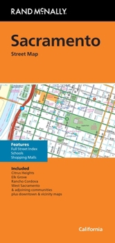
Rand McNally's folded map for Sacramento is a must-have for anyone traveling in and around this part of California, offering unbeatable accuracy and reliability at a great price. Our trusted cartography shows all Interstate, U.S., state, and county highways, along with clearly indicated parks, points of interest, airports, county boundaries, and streets. The easy-to-use legend and detailed index make for quick and easy location of destinations. You'll see why Rand McNally folded maps have been the trusted standard for years. - Regularly updated. - Full-color maps. - Clearly labeled Interstate, U.S., state, and county highways. - Indications of parks, points of interest, airports, county boundaries, downtown & vicinity maps. - Major attractions & Golf Courses. - Easy-to-use legend. - Detailed index & Major Street Index. - Convenient folded size. Coverage Area Communities Included: Citrus Heights, Elk Grove, Rancho Cordova, West Sacramento and adjoining communities plus downtown and vicinity maps. Product Details: Measures 9.5' x 4' and folds out to 40' x 28'.
Format:Mass Market Paperback
Language:English
ISBN:0528028855
ISBN13:9780528028854
Release Date:April 2024
Publisher:Rand McNally
Length:1 Pages
Weight:0.12 lbs.
Dimensions:0.2" x 4.3" x 9.1"
Related Subjects
ReferenceCustomer Reviews
0 rating
Copyright © 2025 Thriftbooks.com
Terms of Use | Privacy Policy | Do Not Sell/Share My Personal Information | Cookie Policy | Cookie Preferences | Accessibility Statement
ThriftBooks ® and the ThriftBooks ® logo are registered trademarks of Thrift Books Global, LLC
ThriftBooks ® and the ThriftBooks ® logo are registered trademarks of Thrift Books Global, LLC
