
Family Maps of Hempstead County, Arkansas
No Customer Reviews

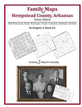
288 pages with 86 total maps Locating original landowners in maps has never been an easy task-until now. This volume in the Family Maps series contains newly created maps of original landowners (patent maps) in what is now Hempstead County, Arkansas, gleaned from the indexes of the U.S. Bureau of Land Management. But it offers much more than that. For each township in the county, there are two additional maps accompanying the patent map: a road map and a map showing waterways, railroads, and both modern and many historical city-centers and cemeteries. Included are indexes to help you locate what you are looking for, whether you know a person's name, a last name, a place-name, or a cemetery. The combination of maps and indexes are designed to aid researchers of American history or genealogy to explore frontier neighborhoods, examine family migrations, locate hard-to-find cemeteries and towns, as well as locate land based on legal descriptions found in old documents or deeds. The patent-maps are essentially plat maps but instead of depicting owners for a particular year, these maps show original landowners, no matter when the transfer from the federal government was completed. Dates of patents typically begin near the time of statehood and run into the early 1900s. What's Mapped in this book (that you'll not likely find elsewhere) . . . 3590 Parcels of Land (with original landowner names and patent-dates labeled in the relevant map) 49 Cemeteries plus . . . Roads, and existing Rivers, Creeks, Streams, Railroads, and Small-towns (including some historical), etc. What YEARS are these maps for? Here are the counts for parcels of land mapped, by the decade in which the corresponding land patents were issued: DecadeParcel-count 1820s85 1830s1433 1840s221 1850s517 1860s565 1870s158 1880s259 1890s198 1900s88 1910s59 1920s7 What Cities and Towns are in Hempstead County, Arkansas (and in this book)? Academy (historical), Alton (historical), Arcadia, Battlefield, Bellair, Belton (historical), Beverly Hills (subdivision), Bingen, Blevins, Centerville, Clow, Coler, Columbus, Compton (historical), Crossroads, Dave, De Ann, Deanyville, Dolph (historical), Dotson, Dotson Station (historical), Doyle, Drab (historical), Dunlap, Eastridge Addition (subdivision), Evening Shade, Forest Hills (subdivision), Frisco Addition (subdivision), Fulton, Garlandville, Georgetown Addition (subdivision), Green Acres (subdivision), Guernsey, Gunter Addition (subdivision), Hempstead Heights (subdivision), Hennessey (historical), Hills of Hope (subdivision), Holcomb Addition (subdivision), Hope, Jakajones (historical), Kilgore (historical), Lester Addition (subdivision), Magnolia Addition (subdivision), McCaskill, McNab, New Hope, North Bingen, Oakhaven, Ozan, Park Addition (subdivision), Patmos, Perrytown, Pines Addition (subdivision), Powers, Rocky Mound, Sardis (historical), Sheppard, Shover Springs, Southridge Estates (subdivision), Spring Hill, Sprudel, Thrasher (historical), Tokio, Wafers Crossing, Wallaceburg, Washington, Westbrook (historical), Yancy
Format:Paperback
Language:English
ISBN:1420311417
ISBN13:9781420311419
Release Date:May 2010
Publisher:Arphax Publishing Co.
Length:298 Pages
Weight:1.81 lbs.
Dimensions:0.6" x 8.5" x 11.0"
Related Subjects
ReferenceCustomer Reviews
0 rating
Copyright © 2025 Thriftbooks.com
Terms of Use | Privacy Policy | Do Not Sell/Share My Personal Information | Cookie Policy | Cookie Preferences | Accessibility Statement
ThriftBooks ® and the ThriftBooks ® logo are registered trademarks of Thrift Books Global, LLC
ThriftBooks ® and the ThriftBooks ® logo are registered trademarks of Thrift Books Global, LLC
